Free Nautical NOAA Charts and Programs
There are two types of charts that would interest the kayaker. The raster charts, electronic copies of regular printed marine maps, are available as Raster Nautical Charts (RNC) charts. Vector charts are more commonly used in on board electronic displays such as GPS and RADAR displays, and are available as Electronic Nautical Charts (ENC) charts. Both types show depths, shoreline features and navigational features. The following discussion will focus on charts that can be printed and carried by the kayaker or used in the planning of kayak trips. For a list of all currently available NOAA printed charts (not just ENC and RNC charts), link to http://nauticalcharts.noaa.gov/mcd/dole.htm
Vector
Charts
The government Office of Coast
Survey offers (free to the public) the vector ENC charts in the S-57 international
exchange format. They are available from
http://www.nauticalcharts.noaa.gov/mcd/enc/download_agreement.htm.
ENC charts are available for most of the United States coasts plus
territories, including the Great Lakes and lower Mississippi River.
Currently (Fall 2008) there are 671 charts. There are no
charts for the section from New London to the Point Judith.
Instructions: Scroll down below the User Agreement and click the [Proceed to NOAA ENC Downloads] to acknowledge the conditions under which the government offers the charts, the next screen allows you to choose a graphical or textual method of browsing the charts. The latest Java file (ignore if you don't understand) is required to operate the graphical version. (I could not get it to work on dialup, but can on broadband.) I found the interface clumsy and could not get it to work. Easier to use is the text version. Once into the text version, at the top, pull down the "Show XX charts a page" menu and click on the maximum number (671 in Fall 2008). This will allow you to search (Use the 'Ctrl F' dialog box) for narra (don't need the full word), or any other unique partial map name. The icon in the left column of the large table gives you a crude low resolution map of the location for that specific chart so you have an idea that you have the right one. You may click as many selection boxes in the right column to download the charts you want. Then at the top of the page click on the "Review Selection" button. After a pause you will see all the maps ordered and can now click the "Order Selections" button. The server will combine all your selections into a single zip file (it is a free order) highlighted in red. Click on the "Download" button and save it in a convenient directory or folder. Unzip the files into a working directory or folder on your computer and use one of the programs below for viewing.
Raster Charts
The government Office of Coast Survey offers the raster RNC charts in BSB format. (“BSB File Format” is a trademark of Maptech, Inc.) They are available from http://nauticalcharts.noaa.gov/mcd/Raster/download.htm. Currently there are 1019 charts.
Instructions: Scroll down below the User Agreement and click the [Proceed to NOAA RNC™ (BSB) Downloads]. Continue as in the instructions above.
Local ENC and RNC charts for the New England area are:
13205 Block Island Sound and Approaches
13218 Marthas
Vineyard to Block Island
13221 Narragansett Bay
13223
Narragansett Bay Incl Newport Harbor ri
13224 Providence R and
Head of Narragansett Bay ri
13225 Providence Harbor
13226 Mt
Hope Bay ri-ma
13227 Fall River Harbor
13228 Westport River and
Approaches
13230 Buzzards Bay
13232 New Bedford Harbor and
Approaches
13246 Cape Cod Bay
13267 Massachusetts Bay
13270
Boston Harbor
13272 Boston Inner Harbor
Additional RNC charts:
13212 Approaches to New London Harbor
13213 New
London Harbor and vicinity;Bailey Point to Smith Cove
13214
Fishers Island Sound
13215 Block Island Sound Point Judith to
Montauk Point
13217 Block Island
13219 Point Judith Harbor
Four Free Programs that allow you to view the Charts:
http://www.fugawi.com/web/products/fugawi_view_enc.htm
(fugviewenc.zip, 4 meg file)
(ENC charts only)
This
program allows fine control of map centering with grab and drag.
Areas can also be defined by cursor and expanded. Of the four
programs this is the easiest to navigate. Up to three maps can be
seamlessly displayed at once, and display options operate on all maps
at once. It allows defining contours and setting the depths in feet
or meter. But it has the least menu options. The only way to save a
map is with a screen
capture program . The saved map can then only be as large as your
computer screen resolution, eg. 1024x768 or 1280x1024.
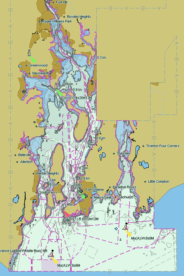
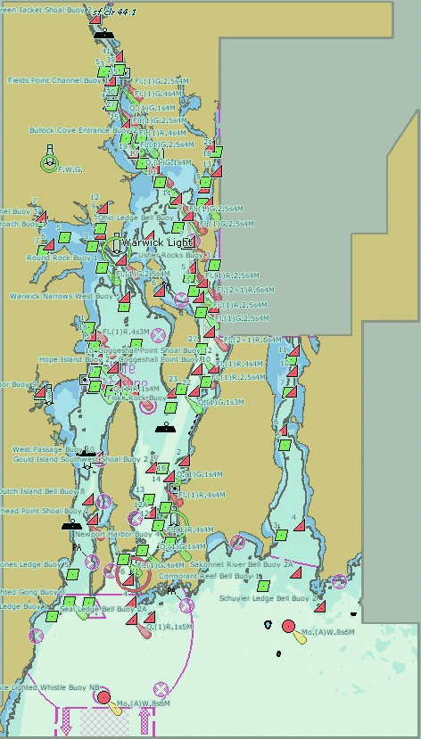
Narragansett Bay overall view with Fugawi View.
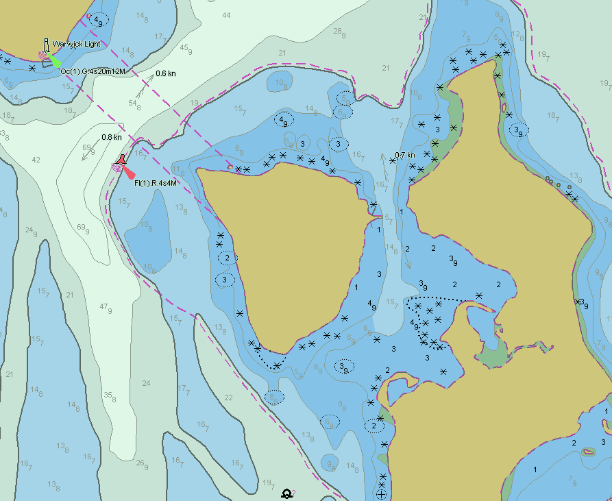
Patience and Prudence Islands with Fugawi View.
http://www.caris.com/products/easy-view/
(CarisEasyView104.exe, 57 meg file)
(ENC
and RNC charts)
You will be required to register for a free download. This program is the largest with
many options. While it can use both ENC
and RNC charts, it can only do one type at a time. It is also very
slow during a refresh after changing options, even with a 2.4 gig Hz
pentium computer. This program is the most difficult to manage and has a learning curve.
Background can be set to day/dusk/night viewing. Centering maps is
limited to 9/10 screen jumps with the cursor keys only, but areas
can be defined by cursor and expanded. The only way to save a map is
with a screen
capture program.
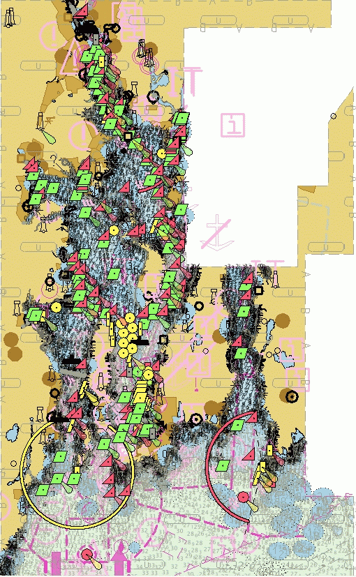
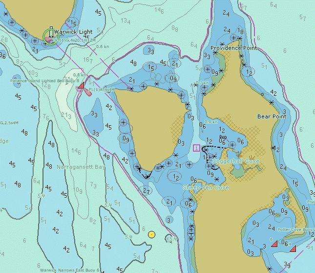
Narragansett Bay overall view with Caris-ENC.
Patience and Prudence Islands with Caris-ENC
http://www.sevencs.com/
(SeeMyDEnc_9x.exe, 10.5 meg file) (ENC
charts only)
This program has many menu options, but
depths are in meters. Only one map can be displayed at a time, which
is a limitation. Text can be in large text for easy reading.
Background can be set to day/dusk/night viewing. Map centering is
limited to ½ screen jumps. The program can save/print the
viewed map without using a screen capture program.
Narragansett Bay overall view with SeeMyDEnc.
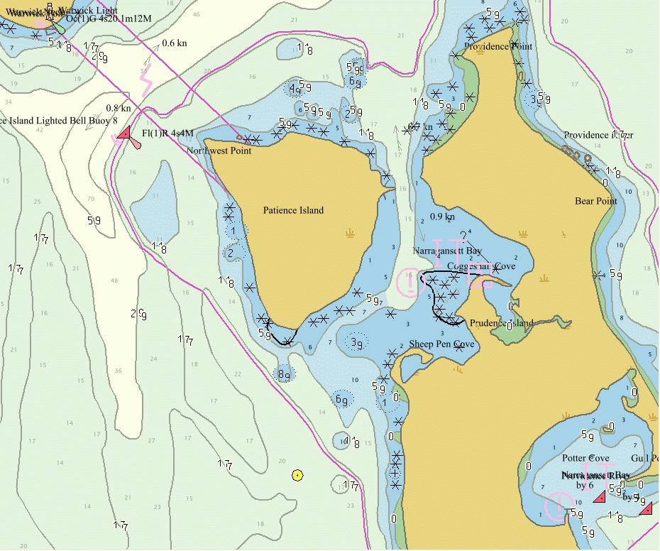
Patience and Prudence Islands with SeeMyDEnc.
http://www.rosepointnav.com/CoastalExplorer/Trial/default.htm
(CETrial11.exe, 23 meg file)
(ENC and RNC charts)
This is a complex and
large program which handles both ENC files and RNC charts. Only one
chart can be viewed at a time but the charts can be very large, such
as the entire Narragansett Bay map. For a viewed area on your
screen, you can easily switch between ENC or RNC charts. The
maps are smoothly zoomable and scrollable. The maps are printable,
and you can preview what will be printed. The size of the print is
dependent on your printer paper size. The most difficult in the
learning curve for this program is the fact that you don't just open
a file to view. The program scans your computer for compatible maps
and gives you a 'Chart Portfolio' to pick from. I found this program
the best if you want a lot of features and are willing to go through
the learning curve, or if you want to work with off-line raster RNC
charts.
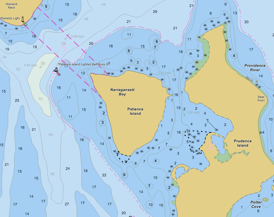
Patience and Prudence Islands with Coastal Explorer using ENC chart.

Patience and Prudence Islands with Coastal Explorer using RNC chart..
rev 11-22-2008